
What happened with the earthquake in Russia, what consequences could it have, and how tsunamis form?
Mike MunayThe world woke up yesterday with a start: a brutal 8.8-magnitude earthquake struck the Pacific Ocean, between Russia and Japan, near the Kamchatka Peninsula, triggering tsunami warnings in several countries. The quake occurred at a depth of approximately 21 kilometers below the seafloor, a detail that makes a difference. Shallower earthquakes (between 0 and 50 km) are those that generate the most dangerous tsunamis because the displacement of the seafloor is transmitted more directly to the water column, pushing it with much greater force. When the earthquake occurs deeper, the energy is dispersed before reaching the surface, and the impact on the water is much less. In this case, the combination of enormous magnitude and relatively shallow depth caused the seafloor to move abruptly, lifting and sinking large blocks of the ocean floor as if they were pieces of a giant piston.
On the Russian coasts closest to the epicenter, waves of up to four meters were already seen, advancing some 200 meters inland, sweeping away piers and damaging local ports. We're talking about a seismic monster: the sixth strongest recorded on the planet since 1900. The energy released is keeping dozens of coastal communities across the ocean on edge. Authorities reacted with the speed required in such a scenario. Japan immediately activated its emergency protocols and ordered the evacuation of nearly two million people due to the risk of waves of up to three meters hitting its coastline. The Pacific Tsunami Warning Center followed suit, issuing warnings for more than fifteen countries. From Kamchatka to Hawaii and the American coast, monitoring systems have not stopped for a second. In Hawaii, in fact, buoys and tide gauges already recorded the first waves, just over one meter, after traveling almost 5,000 kilometers from the epicenter. The relatively shallow depth of the earthquake allowed the energy to interact very effectively with the entire body of water, propagating waves at speeds that, thanks to gravity, reached between 600 and 800 km/h, comparable to those of a commercial airplane.

The epicenter of the Russian earthquake
Source: USGS
This brings us to a question that's on everyone's lips today: how can an underwater earthquake generate waves capable of crossing half the planet and hitting with such force? We're going to dive into the physics behind tsunamis, but we won't stop there. Step by step, we'll answer the most frequently asked questions about these phenomena: how they form, why they can travel so far without losing strength, what determines wave size, and how countries are trying to reduce their impact. Because understanding them is the first step in learning to coexist and survive in the face of one of nature's most relentless forces.
How is it possible for an earthquake in the ocean to generate devastating consequences such as a tsunami tens of thousands of kilometers away?
Tsunamis, also known as tidal waves, are not ordinary wind-driven waves. They are genuine displacements of colossal masses of water caused by sudden shifts in the seafloor. In three out of four cases, the culprit is a large, shallow-sea earthquake, usually greater than magnitude 7.0. For a tsunami to form, it's not enough for the ground to shake: the earthquake must suddenly lift or sink a large portion of the seafloor vertically, pushing up or down the entire column of water above it. It's as if the Earth's crust suddenly acted like a gigantic piston. This movement upsets the ocean's equilibrium, and as it tries to restore it, the energy is transformed into waves that travel across the sea. Not all underwater earthquakes cause tsunamis, but when a massive release of energy combines with a vertical displacement of the seafloor, the result can be devastating.
Once generated, a tsunami expands in all directions across the ocean as long-period, ultra-long waves. Unlike normal waves, which only involve the surface layer, a tsunami sets the entire water column in motion, from the seafloor to the surface. This allows it to carry energy extremely long distances without dissipating significantly. In the deep ocean, these waves can be hundreds of kilometers long but only a few centimeters or meters high at the surface, so they often go unnoticed in the open ocean. In fact, sailors on the high seas would normally not notice a tsunami passing beneath their ship because the uplift is so gentle and broad. However, the speed of propagation is astonishing: as the entire mass of water displaces from the bottom, the wave speed depends on the ocean depth according to the formula v = √(g·D) (where g is gravity and D is depth). At typical depths of 4,000–5,000 m, this translates to speeds of around 600–800 km/h (370–500 mph), comparable to the speed of a jet plane. Thus, in just a few hours, a tsunami can travel thousands of kilometers. For example, waves generated in Kamchatka took about 7 hours to reach Hawaii in the mid-Pacific, and in about 10–12 hours they could cross the entire ocean to South America.
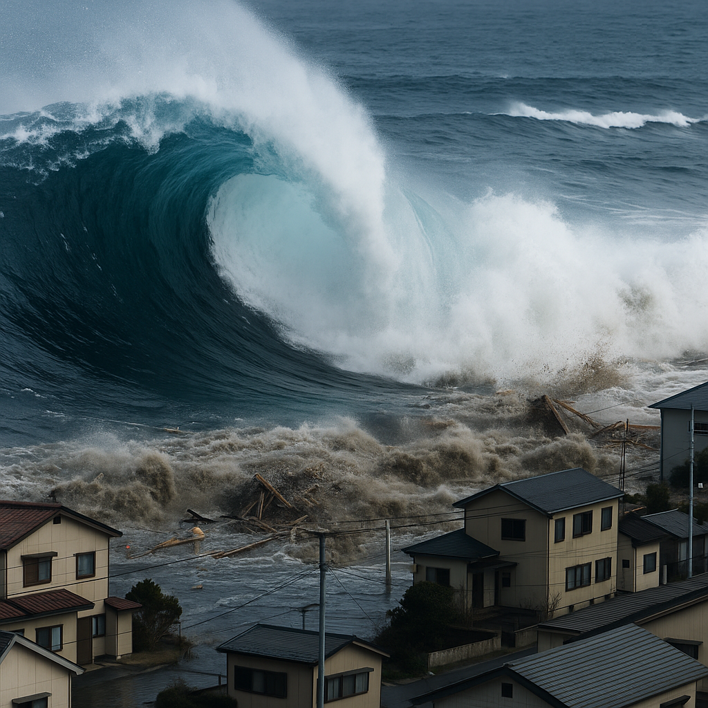
The real danger of a tsunami arises when its waves leave the deep ocean and enter shallow waters near the coast. Upon reaching the continental shelf, the base of the wave "grazes" the seafloor, and its speed plummets: from traveling at hundreds of kilometers per hour on the high seas, it can slow to about 50 km/h near the shore. But this sudden slowdown does not negate its force. The tsunami's energy doesn't disappear; it is simply transformed: the enormous energy of movement it carried in the open ocean is compressed and converted into height, causing the wave to grow suddenly. In other words, what in the open sea appeared to be a long, barely visible ripple becomes, upon reaching land, a veritable wall of water. A wave that barely reached one or two meters on the high seas can multiply its height several times over and rise to more than ten or even twenty meters, depending on the shape and relief of the coast. In extreme situations, the result can be devastating: during the tragic tsunami in Japan in 2011, some areas channeled through coastal valleys recorded water levels reaching 30 or even 40 meters. In today's event, initial estimates pointed to waves of around three meters for the coasts closest to the epicenter, a figure that matches what has already been observed in some parts of Russia.
Another important aspect is that a tsunami does not arrive as a single isolated wave, but rather as a series or train of waves. The disturbance generated by the earthquake produces several waves that travel consecutively. Therefore, after the initial impact, more waves can continue to arrive for several hours. In fact, the first wave is not always the largest; subsequent waves can exceed the height of the initial one. Authorities usually maintain alerts active for at least 3–6 hours after the first impact, until they are sure that the danger has passed. This multiple nature of tsunamis explains why, in emergency protocols, they insist on not returning to evacuated areas too soon and remaining on high ground until further notice. In short, a large underwater earthquake can trigger a tsunami capable of crossing entire oceans quickly, camouflaged on the high seas but lethal when it reaches the coasts, where it releases all its accumulated energy in the form of giant, successive waves.
Preparing countries for tsunami risk
The devastating effects of tsunamis have prompted countries with coastlines in seismic zones to develop increasingly sophisticated preparedness and early warning measures. Japan, for example, has learned harsh lessons from past events (such as the 2011 tsunami) and is now equipped with advanced tsunami response protocols. Thanks to its national J-Alert system, which integrates seismic sensors, ocean buoys, community sirens, and instant mobile phone alerts, the country can disseminate mass evacuation notices in seconds. This model is complemented by supercomputers that model wave behavior in real time, coastal walls in vulnerable areas, and a strong culture of community drills.
In the Pacific Rim, the United States maintains two 24/7 warning centers (the PTWC in Hawaii and the NTWC in Alaska), supported by a complete chain of DART buoys and tide gauges that monitor ocean behavior in real time. When a threat is detected, alerts are disseminated through coastal sirens and the WEA wireless emergency system, which sends geolocated notifications to cell phones. Chile, meanwhile, has one of the strictest protocols on the continent, coordinated by SENAPRED and SHOA, which automatically activates a Red Alert for tsunami risk. Along its coast, evacuation routes are clearly marked, and national drills involving thousands of people are periodically conducted, which has improved the response capacity of its coastal communities.
Peru, also located in the Pacific Ring of Fire, has strengthened its warning system in recent years, led by the Peruvian Geophysical Institute (IGP) and the Directorate of Hydrography and Navigation (DHN) of the Navy, which serves as the National Tsunami Warning Center. These institutions, in coordination with the Pacific Tsunami Warning Center, issue immediate warnings after significant earthquakes and coordinate evacuations through sirens, radio, television, and social media. In addition, mass drills and the marking of evacuation routes have increased in coastal cities such as Lima, Ilo, and Pisco, reinforcing a culture of prevention.
Other countries such as New Zealand, Canada, and Indonesia have also invested in advanced systems: integrated seismic networks, mobile alerts, community education, and international collaboration under the UNESCO framework. Since the tragic Indian Ocean tsunami of 2004, the world has realized that no single system is sufficient: global cooperation, advanced technology, and a trained population are required to confront these disasters.
In all cases, technology is key: DART buoys to detect pressure variations on the ocean floor, coastal tide gauges, real-time computer models, and even artificial intelligence tools that predict wave behavior. But no technical advance replaces preventive education: knowing how to act in the first few minutes can save thousands of lives. Today's events, with a mega-earthquake that triggered alerts from one end of the Pacific to the other, are a reminder that we live on a dynamic and vulnerable planet. And that, although we cannot stop a tsunami, we can prepare to reduce its impact.

DART buoy to detect tsunamis
Quick FAQs about Tsuamis
What is a tsunami and how does it differ from a “giant wave”?
A tsunami is a series of waves triggered by the massive displacement of water , usually caused by an underwater earthquake. Unlike wind waves, a tsunami moves the entire water column (from the bottom to the surface) and carries much greater energy.
How and why does a tsunami form?
Most (about 75% ) are caused by underwater earthquakes : when the seafloor rises or sinks abruptly (magnitude ≥7.0 and shallow), it acts like a piston that pushes the entire water column. Within seconds, this deformation generates a very long wave that propagates through the ocean at high speed. They can also be caused by volcanic eruptions , landslides , or even meteorite impacts.
How fast and far can a tsunami travel?
In the deep sea, waves reach speeds of between 600 and 800 km/h (370 and 500 mph) , similar to the speed of a commercial airplane. Because of this, they can cross entire oceans in just a few hours , reaching thousands of kilometers from the epicenter with much of their energy intact.
Why are they almost invisible in the open sea, but on the coast they become gigantic?
In deep water, a tsunami can be as little as 50 cm high but hundreds of kilometers long , so it goes unnoticed. As it approaches the coast, the seafloor slows the wave base, compressing its energy and causing it to grow into walls of water 10–20 meters or more .
How long does a tsunami last and how many waves does it have?
It's not just a single wave: it arrives as a train of waves that can last for several hours . What's more, the first wave isn't always the largest , so the danger remains even after the first impact.
What natural signs can warn of a tsunami?
A strong earthquake on the coast, a sudden retreat of the sea , or a roaring noise are clear signs to evacuate immediately, even before receiving an official alert.
Why are tsunamis so dangerous?
Because they combine speed, range, and energy : they can cross oceans, devastate kilometers of land, and destroy infrastructure, with a force incomparable to ordinary waves.
Can we predict a tsunami in advance?
We can't predict the earthquake that causes it, but we can detect tsunamis within minutes with buoys, tide gauges, and computer models, buying the time needed to evacuate and save lives.
What do countries do to protect themselves?
They are installing DART buoy networks, tide gauges , and early warning systems, and are training the population with drills and evacuation protocols . Japan, Chile, the United States, New Zealand, and Peru are leading the way in preparation.
Can a tsunami occur anywhere in the world?
Yes, although they are more common in the Pacific Ring of Fire , where several tectonic plates meet. However, they can also occur in the Atlantic, the Indian Ocean, or even in enclosed seas if there are landslides or eruptions.
What would have happened if the earthquake had been in the Sea of Japan?
The impact would have been much worse: the Sea of Japan is more inland , and waves would have reached the coast in a matter of minutes , with less time to react. The energy would have been more concentrated in populated areas, as was the case in 2011.
How does a DART buoy work?
A DART (Deep-ocean Assessment and Reporting of Tsunamis) buoy detects pressure changes on the ocean floor. It has an anchored sensor that measures sea level fluctuations and sends the data to the surface; the buoy transmits the data via satellite to alert centers to activate protocols within minutes.
Have there been tsunamis that changed history?
Yes. The 2004 Indian Ocean earthquake left more than 230,000 dead and transformed international cooperation into warnings. The 2011 earthquake in Japan triggered the Fukushima crisis and redefined the country's energy policy. And the Lisbon earthquake in 1755 marked the political and philosophical course of Europe.
Reflection on scientific innovation
The 8.8 magnitude earthquake that struck the Pacific today reminds us of an uncomfortable truth: the Earth remains a living and dynamic planet, capable of releasing energy in seconds that exceeds that of thousands of atomic bombs. But it also shows us something hopeful: science saves lives. Behind every early warning, every timely evacuation, and every drill, there are decades of research and international cooperation. We cannot stop the force of the ocean, but we can understand it and anticipate it. The difference between tragedy and survival, today more than ever, lies in knowledge.
7 comments
Me ha parecido excelente y muy ameno e interesante el artículo. Gracias!
Excelente contenido.